(2: 中国科学院南京地理与湖泊研究所, 南京 210008)
(3: 湖泊与环境国家重点实验室, 南京 210008)
(2: Nanjing Institute of Geography and Limnology, Chinese Academy of Sciences, Nanjing 210008, P. R. China)
(3: State Key Laboratory of Lake Science and Environment, Nanjing 210008, P. R. China)
粉尘或风沙天气能够改变大气环流, 影响全球的生物地球和水循环, 因此其在全球的气候变化中担任重要角色, 在中国北方, 尤其是干旱、半干旱地区沙尘天气十分普遍, 风成沉积在陆相地层中多有保存[1-3].湖泊作为相对稳定的水体, 对风成物质同样具有良好的保存性, 是研究风沙及粉尘沉积的理想载体[4].沉积物中的石英具有硬度大、化学稳定性强、抗风化能力强、易于采集等特点, 其表面微结构特征能够用于判断沉积物形成的外营力、沉积环境与演化历史等[5-14].多年来, 国内外学者针对各种沉积环境中石英颗粒表面结构特征进行了大量的研究[5-27].形成湖泊沉积物的外营力较复杂, 主要包括水流、风力和冰川搬运作用, 因此, 运用扫描电镜观察湖泊沉积中石英颗粒表面特征, 成为判断湖泊沉积成因的重要手段之一[20-25].库赛湖位于青藏高原北部可可西里地区, 是青海省沙尘天气频发的地区之一[28].库赛湖年纹层发育, 由浅黄褐色的粗颗粒层和浅灰色的细颗粒层组成, 通过对库赛湖年纹层粗细颗粒层的形态特征、矿物组成、生物的发育程度等研究认为, 库赛湖粗、细颗粒层分别由风成和水成作用形成[29].为进一步证实库赛湖年纹层粗颗粒层的风成成因, 本文以库赛湖沉积年纹层为研究对象, 结合青藏高原北部典型沙丘沉积、典型河流沉积、库赛湖冰面风成沉积、库赛湖湖滨相水成粗颗粒沉积, 利用扫描电镜进行上述沉积物石英颗粒表面特征观察研究, 进而揭示库赛湖年纹层粗颗粒层的成因.该研究对于建立区分湖泊沉积物中风成和水成沉积石英颗粒表面形态特征的标志、阐明库赛湖年纹层的形成机理以及利用库赛湖年纹层进行古气候环境重建具有重要的科学意义.
1 研究区域概况库赛湖(35°33'~35°50'N, 92°37'~93°03'E)位于青海省玉树藏族自治州治多县五道乡境内, 青藏高原北部可可西里地区的东部, 湖面海拔4475 m, 湖水面积254.4 km2, 集水面积3700 km2, 水深为10~50 m, 湖泊东南部水域较浅, 约为10 m; 湖泊西北水域较深, 最大深度达50 m(图 1), 补给系数为13.1, 湖水主要接受大气降水和发源于昆仑山南坡五雪峰(5577 m)和大雪峰(5863 m)的库赛河补给[30-31].根据五道梁气象站(距库赛湖以南50 km左右)53 a(1957-2009年)的气象资料, 该地区年平均气温约-5.4℃, 年平均降水量为283 mm; 年平均风速4.4 m/s, 69月的气温通常在0℃以上; 冬季月平均风速明显大于其他季节, 且库赛湖西北临中国最大的沙漠——塔克拉马干沙漠.对青海境内41个气象站(1961-2000年)大风日数和沙尘暴天气等的研究认为, 出现大风的天气情况下经常伴有沙尘暴天气, 库赛湖地区是青海省沙尘天气频发的地区之一[28] (图 1).

|
图 1 青藏高原北部库赛湖及采样位置 Fig.1 The sampling sites and location of Lake Kusai in the Hohxil region of the Tibetan Plateau |
为取得良好的对比效果, 在库赛湖及其周边共采集了3类样品(图 1):①典型的风成样品:库赛湖冰面样品[32]、花土沟至阿尔金沙丘样品(38°5'33″N, 90°5'29″E)和格崖公路沙丘样品(36°40'43″N, 93°46'52″E); ②典型的水成沉积样品:格尔木河下游古河道河流相样品(36°4'39″N, 94°48'55″E)、经库赛湖北部小溪带来的在库赛湖湖滨地带沉积的湖滨相粗颗粒样品(35°43'12″N, 92°58'10″E); ③随机采集的两层来自库赛湖钻孔KS-2010岩芯(35°43'19″N, 92°55'12″E)纹层中的粗颗粒层样品[29].
3 研究方法0.125~0.500 mm石英砂基本为各成因沉积物中的最活跃组分, 表面结构成因组合发育齐全[14,33-34].因此, 分别取风成样品(冬季库赛湖冰面风成物、格崖公路沙丘风成物、花土沟至阿尔金小沙丘风成物)、水成样品(格尔木河古河道河流相沉积物、库赛湖湖滨相粗颗粒沉积物)和钻孔岩芯样品(岩芯中粗颗粒层)各2~3 g, 过30目和120目试验筛, 在浓度为20%的HCl溶液中浸泡、震荡8 h后, 用蒸馏水反复冲洗直至上清液为中性; 再使用浓度为20%的H2O2浸泡、震荡8 h, 用蒸馏水反复冲洗至上清液为中性后烘干.为避免因石英颗粒大小不同可能造成其表面形态特征的不一致, 将烘干的样品置于光学显微镜下, 随机挑选大小为200 μm左右的石英颗粒20粒, 用铜导电胶粘至载样台上, 抽真空并喷镀金膜, 喷金处理电流为8 mA, 并将样品正面、左面与右面各喷30 s, 共计90 s.石英颗粒的表面观察分别利用首都师范大学分析测试中心的SU8010扫描电子显微镜和中国地质大学(北京)的Zeiss supra 55场发射扫描电镜完成.
目前, 国内外对于石英颗粒表面微形貌特征的研究较深入, 但不同学者采用的石英颗粒表面微形貌特征略有不同[5-27], Vos等[8]较全面地总结了34种石英颗粒表面微形貌特征, 这些微形貌特征能够较好地反映石英沉积的环境特征, 因此, 本研究主要采用Vos等总结的34种石英颗粒表面微形貌特征[8], 并增加了能够很好地区分风成和水成成因的碟形坑这一石英颗粒表面微形貌特征[11](表 1), 对本研究的所有样品进行35个形貌特征的观察和统计.
| 表 1 本研究采取的35种石英颗粒表面微形貌特征 Tab.1 35 kinds of surface microtextures of quartz grains in this research |
由于有些石英颗粒表面特征并不局限存在于一种环境, 因此不宜用一种表面特征或局部特征来判别石英颗粒的形成环境[5, 10, 16, 19].因而本文选择采用出现频率统计分析的方法判断石英颗粒表面特征的沉积环境.
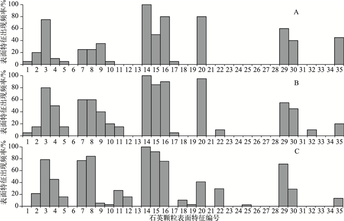
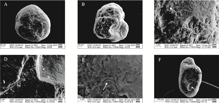
4.1 风成石英颗粒表面特征如图 2所示, 库赛湖地区典型风成石英颗粒表面明显具有圆形轮廓(图 3A)、球根状边缘(图 3A)、中低浮雕(图 3A、3B)、翻板(图 3C)、直形阶梯、弓形阶梯(图 3D)、新月型撞击坑(图 3E)、碟形坑(图 3F)等特征.其中翻板特征均达到100%, 格崖公路沙丘、花土沟至阿尔金沙丘及库赛湖冰面风成样品圆形轮廓特征分布频率分别为75%、80%和78.6%, 球根状边缘分布频率分别为80%、90%和75.85%.其中风成沙丘与库赛湖冰面风成样品同样存在少量差异, 例如:冰面风成样品碟形坑分布相对较少, 出现频率只有40%左右, 而风成沙丘样品出现频率可以达到80%以上(图 2).
|
图 2 风成石英颗粒表面特征统计(石英颗粒表面特征编号与表 1的编号相对应, 下同): A.格崖公路沙丘样品; B.花土沟至阿尔金沙丘样品; C.库赛湖冰面风成样品 Fig.2 The statistical figure of surface features of quartz grains in aeolian sediments (The numbers of microtextures correspond to those listed in Tab. 1, the same below): A. Dune samples near the highway from Golmud to Manya (DGM); B. Dune samples near the road from Huatugou town to Altun Mountains (DHA); C. Aeolian dust samples deposited in the ice of Lake Kusai (ALK) |
|
图 3 风成石英颗粒表面形态特征: A.格崖公路沙丘样品, 圆形轮廓、低浮雕、球根状; B.花土沟至阿尔金沙丘样品, 圆形轮廓、中浮雕; C.花土沟至阿尔金沙丘样品, 翻板(箭头所示); D.格崖公路沙丘样品, 直形阶梯(a)、弓形阶梯(b); E.库赛湖冰面风成样品, 新月形撞击坑(箭头所示); F.花土沟至阿尔金沙丘样品, 碟形坑(箭头所示) Fig.3 The typical surface microtextures of quartz grains in aeolian sediments: A. Rounded outline, low relief, and bulbous edges. DGM; B. Rounded outline, medium relief. DHA; C. Upturned plates (arrow). DHA; D. Straight (a) and arcuate steps(b). DGM; E. Crescentic percussion marks (arrow). ALK; F. Dish shaped depression (arrow). DHA |
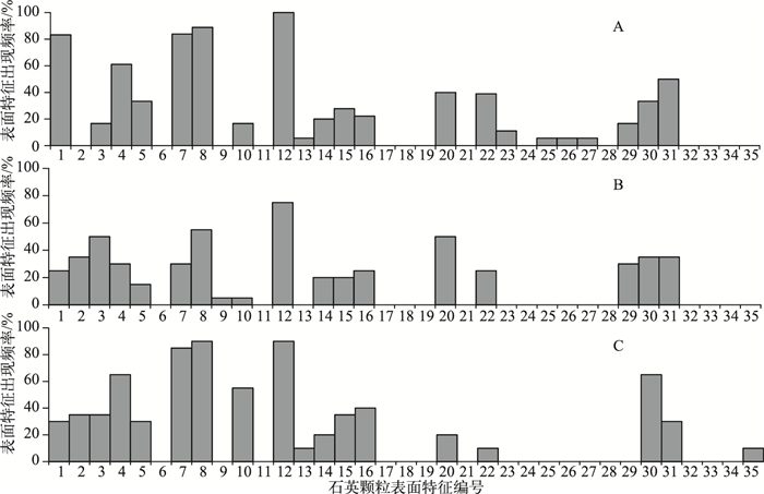
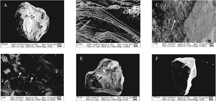
库赛湖湖滨相样品与格尔木河下游古河道河流相沉积样品石英颗粒表面特征略存在差异(图 4), 如库赛湖湖滨相样品和格尔木河下游古河道河流相(下层)样品中的石英颗粒磨圆不均, 3种磨圆程度均存在(棱角轮廓、半棱角轮廓和圆形轮廓), 且出现频率相当, 而格尔木河下游典型河流相沉积(上层)样品磨圆较差, 棱角轮廓占80%以上, 这种微小的差异可能同它们形成时的水动力条件不同有关.但总体而言, 格尔木河古河道河流相及库赛湖湖滨相样品中的石英颗粒具有较为相同的表面形态特征, 具体地表现在这些水成沉积物中的石英颗粒主要以棱角或半棱角轮廓(图 5A、E、F)、中浮雕和高浮雕(图 5A、F)形式出现, 表面结构中V型撞击坑(图 5C)、贝壳状断口(图 5E)十分发育, 并见少量平行节理面(图 5F)、溶蚀坑(图 5D)等微形貌, 其中V型撞击坑出现频率均超过75%, 甚至高达100%.可以看出, 上述水成沉积物中石英颗粒表面特征同风成石英颗粒表面特征相比差异较大.
|
图 4 水成石英颗粒表面特征统计: A.格尔木河下游古河道河流相沉积(上层)样品; B.格尔木河下游古河道河流相沉积(下层)样品; C.库赛湖湖滨相沉积样品 Fig.4 The statistical figure of surface features of quartz grains in fluvial sediments: A. Fluvial sediments in paleochannel in lower reaches of Golmud River (upper layer) (FGRU); B. Fluvial sediments in paleochannel in lower reaches of Golmud River (lower layer) (FGRL); C. Lacustrine deposits in the lakeside of Lake Kusai (LLK) |
|
图 5 水成沉积物石英颗粒表面形态特征: A.格尔木河下游古河道河流相沉积(上层)样品, 棱角轮廓、高浮雕; B.库赛湖湖滨相沉积样品, 弓形阶梯; C.库赛湖湖滨相沉积样品, V型撞击坑(箭头所示); D.格尔木河下游古河道河流相沉积(上层)样品, 溶蚀坑(箭头所示); E.格尔木河下游古河道河流相沉积(上层)样品, 半棱角轮廓、中浮雕、小(a)、中(b)贝壳状断口; F.格尔木河下游古河道河流相沉积(上层)样品, 棱角轮廓、高浮雕、平行节理面(箭头所示) Fig.5 The typical surface microtextures of quartz grains in fluvial sediments: A. Angular outline, high relief. FGRU; B. Arcuate steps. LLK; C. V-shaped percussion cracks (arrow). LLK; D. Solution pits (arrows). FGRU; E. Subangular outline, medium relief, small (a) and medium (b) conchoidal fractures. FGRU; F. Angular outline, high relief, and flat cleavage surface (arrow). FGRU |
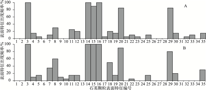
随机采集的库赛湖KS-2010孔岩芯纹层中两组粗颗粒层的石英颗粒表面特征出现频率统计如图 6所示, 可以看出, 库赛湖粗颗粒层石英颗粒整体磨圆较好, 表现为石英颗粒大都呈现出圆形轮廓(图 7A)、低浮雕(图 7A)、球根状边缘(图 7A)等特征, 翻板(图 7B)、新月形撞击坑(图 7C)、碟形坑(图 7D)等十分发育, 还存在有直形、弓形阶梯(图 7E、7F)、等级弧(图 7G)等特征.其中圆形轮廓、翻板及球根状边缘特征出现频率均达到100%, 新月型撞击坑和碟形坑的出现频率分别达到了90%和85%, 均属于大量出现.同时存在少量水成和化学成因特征, 例如平行光条纹、覆瓦状磨削特征、定向溶蚀坑、溶蚀坑、溶蚀裂缝(图 7H)等.
|
图 6 库赛湖纹层粗颗粒层石英颗粒表面特征统计: A、B分别为粗颗粒层随机采取的两个样品 Fig.6 The statistical figure of surface features of quartz grains in coarse particle layer from varved sediments of Lake Kusai: A and B represent two coarse grained layers randomly chosen |

|
图 7 库赛湖年纹层粗颗粒层石英颗粒表面形态特征: A.圆形轮廓、低浮雕、球根状边缘; B.翻板; C.新月形撞击坑(箭头所示); D.碟形坑(箭头所示); E.直形阶梯(箭头所示); F.弓形阶梯(箭头所示); G.等级弧; H.定向溶蚀坑(a)、溶蚀坑(b)、溶蚀裂缝结构(c) Fig.7 The typical surface microtextures of quartz grains in the coarse-grained layers of varved sediments in Lake Kusai: A. Rounded outline, low relief, and bulbous edges; B. Upturned plates; C. Crescentic percussion marks (arrow); D. Dish shaped depression (arrow); E. Straight steps (arrow); F. Arcuate steps (arrow); G. Graded arcs; H. Oriented etch pits (a), solution pits (b), solution crevasses (c) |
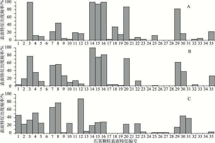
210Pb/137Cs、14C测年、纹层计年的研究结果表明库赛湖的纹层为年纹层[29], 年纹层的层偶由浅黄褐色的粗颗粒层和灰白色的细颗粒层组成.湖泊沉积物中粗颗粒物质通常可以由径流、冰川和风力3种搬运作用形成.利用扫描电镜对库赛湖年纹层粗颗粒层石英颗粒表面特征的研究表明, 库赛湖粗颗粒层石英颗粒具有圆形轮廓、低浮雕、翻板、新月形撞击坑、球根状边缘等特征(图 6、7、8), 这些特征与库赛湖周边的沙丘、库赛湖冰面的风成砂等典型风成物石英颗粒表面特征极为相似(图 2、3、8), 而与格尔木河古河道河流相、库赛湖湖滨相等水成沉积物石英颗粒表面特征所具有的棱角或半棱角轮廓、中浮雕和高浮雕、V型撞击坑、贝壳状断口、平行节理面、溶蚀坑等微形貌特征明显不同(图 4、5、8).尽管冰川作用同样可以给湖泊沉积物带来粗颗粒物质, 但大量研究表明:冰川作用带来的粗颗粒沉积石英颗粒表面特征通常具有棱角状、高浮雕、大贝壳状断口等特征[15-19].这些特征显然与库赛湖粗颗粒层石英颗粒的表面特征不同.因此, 库赛湖年纹层粗颗粒层是由风力搬用作用形成的.库赛湖地区是青海省沙尘天气频发的中心之一[28], 且冬季月平均风速明显大于其他季节, 该地区年平均气温约-5.4℃, 易使库赛湖冬季结冰, 强劲的风力作用带来的风成物能够在库赛湖冰面上保存下来, 翌年春季冰面融化后, 风成物沉降至湖底, 从而形成库赛湖年纹层的粗颗粒层.
|
图 8 库赛湖粗颗粒层(A)与风成沉积(B)、水成沉积(C)石英颗粒表面特征出现频率对比: A为图 6A和B的平均结果; B为图 2A、B、C的平均结果; C为图 4A、B、C的平均结果 Fig.8 The comparison chart about surface characteristics of quartz grains in the coarse-grained layers of varved sediments in Lake Kusai(A), aeolian sediments(B) and fluvial sediments(C): A is an average of A and B in Fig. 6, B is an average of A, B and C in Fig. 2, and C is an average of A, B and C in Fig. 4 |
利用扫描电镜对库赛湖地区典型风成物、典型水成物、库赛湖年纹层粗颗粒层中的石英颗粒表面特征进行观察和研究, 得出如下结论:库赛湖地区典型风成物石英颗粒表面具有圆形轮廓、中低浮雕、翻板、新月型撞击坑、球根状边缘、直形阶梯、弓形阶梯、碟形坑等微形貌特征; 典型水成物石英颗粒表面具有棱角或半棱角轮廓、中浮雕和高浮雕、V型撞击坑、小型和中型贝壳状断口、少量溶蚀坑等微形貌特征; 库赛湖年纹层粗颗粒层石英颗粒表面则具有圆形轮廓、低浮雕、翻板、新月形撞击坑、球根状边缘、碟形坑等特征, 其特征与研究区典型风成物的石英颗粒表面特征极其相似, 而明显与研究区典型水成物的石英颗粒表面特征差别很大.因此, 库赛湖年纹层中的粗颗粒层是由风成作用形成的.由于库赛湖地区冬季风速或沙尘天气明显大于其他季节, 且库赛湖冬季易结冰, 风成物在冬季被保留在库赛湖冰面上, 翌年冰融化后, 风成物沉至湖底, 从而形成粗颗粒层.
致谢: 感谢中国地质大学(北京)硕士研究生王曦同学在扫描电镜实验中的帮助.| [1] |
Dong Guangrong, Li Baosheng, Gao Shangyu et al. Discovery and significance of eolian sands in Ordos plateau during the Quaternary period. Chinese Science Bulletin, 1983(16): 998-1001. [董光荣, 李保生, 高尚玉等. 鄂尔多斯高原第四纪古风成沙的发现及其意义. 科学通报, 1983(16): 998-1001.] |
| [2] |
Su Zhizhu, Dong Guangrong, Li Xiaoqiang et al. The lake-swamp sediment records on the environmental characteristics of Mu Us desert since the late glacial epoch. Journal of Desert Research, 1999(2): 104-109. [苏志珠, 董光荣, 李小强等. 晚冰期以来毛乌素沙漠环境特征的湖沼相沉积记录. 中国沙漠, 1999(2): 104-109.] |
| [3] |
Li Baosheng, Dong Guangrong, Gao Shangyu et al. Analysis and discussion on the grain size of the quaternary strata profile in Yu Lin area of the northern, Shan Xi. Acta Geographica Sinica, 1988, 43(2): 127-132. [李保生, 董光荣, 高尚玉等. 陕西北部榆林第四纪地层剖面的粒度分析与讨论. 地理学报, 1988, 43(2): 127-132.] |
| [4] |
Shen J, Wang Y, Yang XD et al. Paleosandstorm characteristics and lake evolution history deduced from investigation on lacustrine sediments-The case of Hongjiannao Lake, Shaanxi Province. Chinese Science Bulletin, 2006, 51(1): 87-92. |
| [5] |
Bull PA. Environmental reconstruction by electron microscopy. Progress in Physical Geography, 1981, 5(3): 368-397. DOI:10.1177/030913338100500302 |
| [6] |
Krinsley DH, Donahue J. Environmental interpretation of sand grain surface textures by electron microscopy. Geological Society of America Bulletin, 1968, 79(6): 743-748. DOI:10.1130/0016-7606(1968)79[743:EIOSGS]2.0.CO;2 |
| [7] |
Frihy OE, Stanley DJ. Quartz grain surface textures and depositional interpretations, Nile Delta region, Egypt. Marine Geology, 1987, 77(3/4): 247-255. |
| [8] |
Vos K, Vandenberghe N, Elsen J. Surface textural analysis of quartz grains by scanning electron microscopy (SEM):From sample preparation to environmental interpretation. Earth-Science Reviews, 2014, 128: 93-104. DOI:10.1016/j.earscirev.2013.10.013 |
| [9] |
Margolis SV, Krinsley DH. Processes of formation and environmental occurrence of microfeatures on detrital quartz grains. American Journal of Science, 1974, 274: 449-464. DOI:10.2475/ajs.274.5.449 |
| [10] |
Chen Lihua, Miao Xin, Yu Zhong. The practical application of transmission electron microscope in geology. Beijing: Science Press, 1986, 21-44. [陈丽华, 缪昕, 于众. 扫描电镜在地质学上的应用. 北京: 科学出版社, 1986, 21-44.]
|
| [11] |
Xie Youyu. Micrograph atlas of surface textural features of quartz sand in China. Beijing: Ocean Press, 1985, 1-148. [谢又予. 中国石英砂表面结构特征图谱. 北京: 海洋出版社, 1985, 1-148.]
|
| [12] |
Wang Yongyen, Teng Zhihong, Yue Leping. Surface texture of quartz grains under the scanning electron microscope and the genesis of loess in China. Acta Geographica Sinica, 1982, 37(1): 35-40. [王永焱, 滕志宏, 岳乐平. 黄土中石英颗粒表面结构与中国黄土的成因. 地理学报, 1982, 37(1): 35-40.] |
| [13] |
Li Zhen, Zhang Jiawu, Ma Haizhou. Discussion on the texture features of quartz grains and their origin in the Xining Loess. Acta Sedimentologica Sinica, 1999, 17(2): 221-224. [李珍, 张家武, 马海洲. 西宁黄土石英颗粒表面结构与黄土物质来源探讨. 沉积学报, 1999, 17(2): 221-224.] |
| [14] |
Fang Xiaomin.Discussion on the material sources and fomation of the loess and environment change from surface features of the loess quartz sand in LanZhou//Research centre of quaternary glaciations and environment in China, Chinese quaternary research committee.Quaternary glaciations and environment in west of China.Beijing:Science Press, 1991:138-148(in Chinese). [方小敏. 试从兰州地区黄土石英砂表面特征探讨黄土物质来源、成因及环境变迁//中国第四纪冰川与环境研究中心, 中国第四纪研究委员会编. 中国西部第四纪冰川与环境. 北京: 科学出版社, 1991: 138-148. ]
|
| [15] |
Whalley WB, Krinsley DH. Scanning electron microscope study of surface textures of quartz grains from glacial environments. Sedimentology, 1974, 21(1): 87-105. DOI:10.1111/sed.1974.21.issue-1 |
| [16] |
Setlow LW, Karpovich RP. "Glacial" microtexture on quartz and heavy mineral sand grain from the littoral environment. Journal of Sedimentary Petrology, 1972, 42(4): 864-875. DOI:10.1306/74D7265D-2B21-11D7-8648000102C1865D |
| [17] |
Mahaney WC, Vaikmae R, Vares K. Scanning electron microscopy of quartz grains in supraglacial debris, Adishy Glacier, Caucasus Mountains, USSR. Boreas, 1991, 20(4): 395-404. |
| [18] |
Mahaney WC, Claridge G, Campbell I. Microtextures on quartz grains in tills from Antarctica. Palaeogeography, Palaeoclimatology, Palaeoecology, 1996, 121(12): 89-103. |
| [19] |
Shi Lei, Zhang Yue, Chen Yixin et al. Quartz grain SEM microtextures analyses of sub-glacial deposits at Hailuogou Glacier. Acta Scientiarum Naturalium Universitatis Pekinensis, 2010, 46(1): 96-102. [石磊, 张跃, 陈艺鑫等. 贡嘎山海螺沟冰川沉积的石英砂扫描电镜形态特征分析. 北京大学学报:自然科学版, 2010, 46(1): 96-102.] |
| [20] |
Mahaney WC. Macrofabrics and quartz microstructures confirm glacial origin of Sunnybrook drift in the Lake Ontario Basin. Geology, 1990, 18(2): 145-148. DOI:10.1130/0091-7613(1990)018<0145:MAQMCG>2.3.CO;2 |
| [21] |
Shi Xingmin, Xu Suing. Environmental significance and characteristics of sands of Manas River Lacustrine Plain. Research of Soil and Water Conservation, 2007, 14(6): 157-159. [史兴民, 徐素宁. 新疆玛纳斯河湖积平原中砂物质的特征与环境意义. 水土保持研究, 2007, 14(6): 157-159.] |
| [22] |
Li Yu, Zhou Xuehua, Li Zhuolun et al. Formation of Holocene Sand Layers by SEM Analyses in the Zhuye Lake Sediments. Acta Sedimentologica Sinica, 2013, 31(1): 149-156. [李育, 周雪花, 李卓仑等. 基于扫描电镜分析的猪野泽全新世砂层成因讨. 沉积学报, 2013, 31(1): 149-156.] |
| [23] |
Li Minghui, Kang Shichang, Zheng Mianping. Surface textures on quartz grains from the Zhabuye Saline Lake in the middle Tibet Plateau since 142 ka BP. Journal of Glaciology and Geocryology, 2008, 30(1): 125-130. [李明慧, 康世昌, 郑绵平. 青藏高原中部扎布耶茶卡142ka以来石英砂表面特征及环境意义. 冰川冻土, 2008, 30(1): 125-130.] |
| [24] |
Bull PA, Culver SJ. An application of scanning electron microscopy to the study of ancient sedimentary rocks from the Saionia Scarp, Sierra Leone. Palaeogeography, Palaeoclimatology, Palaeoecology, 1979, 26: 159-172. DOI:10.1016/0031-0182(79)90147-0 |
| [25] |
Mahaney WC, Dirszowsky RW, Milner MW et al. Quartz microtexture sand microstructures owing to deformation of glaciolacustrine sediments in the northern Venezuelan Andes. Journal of Quaternary Science, 2004, 19(1): 23-33. DOI:10.1002/(ISSN)1099-1417 |
| [26] |
Song Chunhui, Meng Qingquan, Xia Weimin et al. The eogene surface texture of quartz sand and paleoclimatic change in northern margin of Tibetan Plateau. Acta Sedimentologica Sinica, 2009, 27(1): 94-103. [宋春晖, 孟庆泉, 夏维民等. 青藏高原北缘古近纪石英砂表面特征及其古环境意义. 沉积学报, 2009, 27(1): 94-103.] |
| [27] |
Cui Xiaozhuang, Jiang Xinsheng, Wu hao et al. Surface microscopic characteristics of quartz sand grains in the Paleogene Baoxiangsi Formation of Lijiang-Jianchuan area, northwestern Yunnan. Geological Bulletin of China, 2011, 30(8): 1238-1244. [崔晓庄, 江新胜, 伍皓等. 云南西北部丽江-剑川地区古近纪宝相寺组石英砂颗粒表面特征. 地质通报, 2011, 30(8): 1238-1244.] |
| [28] |
Zhao Qiang, Zhou Yuping. Distribution of dust-strom and its relation to wind in Qinghai Province. Journal of QingHai Meteorology, 2002(3): 12-16. [赵强, 周余萍. 青海沙尘暴分布特征及其与大风天气的关系. 青海气象, 2002(3): 12-16.] |
| [29] |
Liu XQ, Yu ZT, Dong HL et al. A less or more dusty future in the Northern Qinghai-Tibetan Plateau?. Scientific Reports, 2014, 4: 6672. DOI:10.1038/srep06672,2014,1-6 |
| [30] |
Li Bingyuan. Natural environment of Hoh Xil region in Qinghai Province. Beijing: Science Press, 1996, 1-15. [李炳元. 青海可可西里地区自然环境. 北京: 科学出版社, 1996, 1-15.]
|
| [31] |
Wang Sumin, Dou Hongshen. Lakes in China. Beijing: Science Press, 1998, 482. [王苏民, 窦鸿身. 中国湖泊志. 北京: 科学出版社, 1998, 482.]
|
| [32] |
Liu Xingqi, Yao Bo, Yang Bo. Grain size distribution of Aeolian and lacustrine sediments of Kusai Lake in tie Hoh Xil region of the northern QingHai-Tibetan Plateau. Quaternary Sciences, 2010, 30(6): 1193-1198. [刘兴起, 姚波, 杨波. 青藏高原北部可可西里库赛湖沉积物及风成物的粒度特征. 第四纪研究, 2010, 30(6): 1193-1198.] |
| [33] |
Fang Xuemin, Wan Zhaohui, Kuang Shangfu. Mechanism and effect of silt-arrest dams for sediment reduction in the middle Yellow River basin. Journal of Hydraulic Engineering, 1998(10): 49-52. [方学敏, 万兆惠, 匡尚富. 黄河中游淤地坝拦沙机理及作用. 水利学报, 1998(10): 49-52. DOI:10.3321/j.issn:0559-9350.1998.10.011] |
| [34] |
Li Jing, Zhang Jinzhu, Wang Xiao. Viewing silt retention dam constructions by looking at rainstorm in the middle reaches of the Yellow River in the 1970s. China Water Resources, 2003(9): 55-57. [李靖, 张金柱, 王晓. 20世纪70年代淤地坝水毁灾害原因分析. 中国水利, 2003(9): 55-57.] |
 2016, Vol. 28


