(2: 西南林业大学农村污水处理研究所, 昆明 650224)
(3: 西南林业大学林学院, 昆明 650224)
(2: Research Institute of Rural Sewage Treatment, Southwest Forestry University, Kunming 650224, P. R. China)
(3: Forestry College, Southwest Forestry University, Kunming 650224, P. R. China)
河口湿地作为削减流域物质输入湖泊的最后天然屏障,具有拦截入湖污染、恢复水陆生态系统功能、维持湖泊水质、改善湖湾生态景观等重要作用[1-2].河口湿地沉积物是氮、磷等污染物的存储库,在外源得到控制时,沉积物在一定程度上能充当营养源的作用,被吸附在沉积物中的营养物质能通过解析、溶解等作用返回上覆水体,形成湿地营养源的内负荷,影响河口湿地水质和削减效果[3-5].河口湿地不仅是削减入湖污染、保护湖泊的最后屏障,而且对控制湖泊富营养化具有重要作用.因此,河口湿地的治理和保护显得尤为重要.当前,我国学者对湖泊、水库沉积物碳、氮、磷和重金属污染进行了大量研究,如王佩等[6]研究了太湖湖滨带底泥氮、磷、有机质的分布与污染评价;赵兴青等[7]采集了不同季节太湖梅梁湾和贡湖底泥柱样,研究了底泥营养盐含量的垂直变化;卢少勇等[8]研究了长寿湖表层沉积物氮、磷和有机质污染特征并对其进行评价;张清海等[9]研究了贵州草海典型高原湿地表层沉积物重金属的积累、分布与污染评价;赵海超等[10]研究了洱海沉积物中不同形态磷的时空分布特征;陈永川等[11]研究了滇池沉积物总磷(TP)的时空分布特征;张玉玺等[12]研究了阳宗海沉积物中磷的分布及其影响因素;张娜等[13]对青藏高原典型湖泊湖岸带表层沉积物碳、氮、磷进行了分析;但关于国内高原河口湿地沉积物碳、氮、磷的分布及污染现状的研究鲜见报道.
罗时江河口湿地位于云南高原湖泊洱海北部湖湾入水口处,其在削减罗时江上游农业面源污染、控制洱海湖泊富营养中发挥着重要作用.近年来,随着洱海流域旅游业、工业的发展,外源污染加重,罗时江河口湿地沉积物积累了大量的污染物质,在适当的条件下释放到水体中,从而加剧了洱海的水体富营养化的风险.本研究通过对罗时江河口湿地不同分区和两条主水流通道沉积物的分析,揭示其总氮(TN)、TP和有机质(OM)的分布特征并对其污染水平进行评价,旨在系统全面阐明罗时江河口湿地沉积物污染现状及来源,为罗时江河口湿地沉积物污染防治和生态环境保护提供科学依据.
1 研究区概况罗时江发源于大理市洱源县西湖,是洱海北部3条主要入湖河流之一,流经右所、邓川、上关三乡镇,在沙坪九孔桥注入洱海,全长18.29 km.流量在丰水期约为13.0 m3/s,枯水期为2.0 m3/s,占洱海总来水量的13 %.据本项目监测结果,2013年罗时江水质TP指标超过《地表水环境质量标准》(GB 3838-2002)中的Ⅴ类标准(年平均浓度为0.68 mg/L),无法满足《洱海流域保护治理规划(2003-2020)》所要求的“Ⅱ类标准”.
罗时江河口湿地是削减罗时江携带的农业面源污染物、保护洱海水质的最后屏障,位于洱海北部湖湾(25°56′52.8″~25°57′24.9″N,100°05′59.9″~100°06′5.9″E),面积约0.5 km2.研究区属北亚热带高原季风气候区,年均温度为15.6℃,年均降雨量约为942 mm.湿地西北和东北部分别有罗时江、黑泥沟携带大量的泥沙、磷污染物注入.湿地内植被多为人工栽植的水生植物,其中挺水植物主要有芦苇(Phragmites australis)、荷(Nelumbo nucifera)、梭鱼草(Pontederia cordata)、再力花(Thalia dealbata)、香蒲(Typha orientalis Presl)、菰(Zizania latifolia);沉水植物主要有金鱼藻(Ceratophyllum demersum)、微齿眼子菜(Potamogeton maackianus)、黑藻(Hydrilla verticillata);浮叶植物主要有睡莲(Nymphaea)等.
2 研究方法 2.1 样品采集与分析本研究采用网格法布点,网格大小为100 m×100 m,去除无效网格(如整个网格中为小岛或无水淹没区),罗时江河口湿地中共划分为45个网格,在网格中心处取样,其中23#、28#、30#、31#、33#、34#、35#、36#样点网格由于被小岛分割,未在网格中心取样,根据地形条件及水流状况增加1~2个采样点,增加后采样点共有55个(图 1).原罗时江河流位置,目前是罗时江河口湿地主水流通道Ⅰ(样点为:1#、14#、25#、34A#、38#);原黑泥沟河流位置,目前是罗时江河口湿地主水流通道Ⅱ(样点为:2#、3#、12#、42#、43#).

|
图 1 罗时江河口湿地区位(a)及样点布置(b) Fig.1 Location of study area(a) and sampling sites(b) in estuarine wetland of Luoshi River |
采样时间为2014年11月20日,利用柱状底泥采样器采集0~10 cm表层沉积物,取样后放入便携式冷恒温箱带回实验室分析沉积物中TN、TP和OM含量.沉积物TN、TP和OM指标分析方法分别采用高氯酸-硫酸消化法(LY/T 1228-1999)、酸熔-钼锑抗比色法(LY/T 1232-1999)和重铬酸钾氧化-外加热法(LY/T 1237-1999).
2.2 数据处理与分析数据处理及其相关分析采用Excel 2007与SPSS 16.0软件.
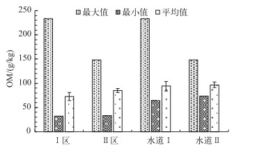
3 结果与讨论 3.1 OM分布特征OM是沉积物是湖泊内源污染的重要指标,也是反映有机营养程度的重要标志[7, 14].罗时江河口湿地沉积物OM含量在32.43~233.03 g/kg之间,平均值为78.54 g/kg,平均值由高到低依次为:水道Ⅰ<水道Ⅱ,Ⅰ区<Ⅱ区.水道Ⅰ的OM含量最大值、最小值和平均值分别为233.03、64.29和94.08 g/kg;水道Ⅱ的OM含量最大值、最小值和平均值分别为147.85、73.90和96.84 g/kg;Ⅰ区的OM含量在32.43~233.03 g/kg之间,平均值为72.57 g/kg;Ⅱ区的OM含量在32.68~147.85 g/kg之间,平均值为84.74 g/kg(图 2).易文利等[15]研究认为长江中下游11个浅水湖泊沉积物中OM含量在9.80~110.00 g/kg之间,平均值为37.20 g/kg;赵海超等[18]研究表明,洱海表层沉积物中OM含量在25.70~148.9 g/kg之间,平均值为52.0 g/kg,可见罗时江河口湿地表层沉积物中OM含量较高,潜在释放风险较高.

|
图 2 罗时江河口湿地表层沉积物中OM含量的分布特征 Fig.2 Distribution of organic matter contents in the surface sediments of the estuarine wetland of Luoshi River |
有资料显示,富营养化水体中沉积物中所含OM一般来自生活污水和水生动植物残体长期沉积[16-17],这些有机残体经过湿地生物的分解及矿化,不断与水体发生交换,逐步沉积和埋藏于沉积物中,其在湖泊营养盐交换过程中却起着举足轻重的作用[18].罗时江河口湿地水道Ⅱ和Ⅱ区沉积物OM含量高于水道Ⅰ和Ⅰ区,可能与有机质长期沉降累积、水体流动性和船运等有关. Ⅱ区水域分布面积较宽,水流从Ⅰ区水道急速流至Ⅱ区,水域变宽,流速变缓,沉积作用加剧使得沉积物OM含量较高. OM含量的高低不仅与水体沉积作用有关,而且与人类的活动如船运、养殖活动等也有密切关系.据现场调查,Ⅱ区和水道Ⅱ为湿地观光船的主要运行区域,频繁的人为扰动促进了沉积物对OM的吸附.此外,在湿地恢复建设之前Ⅱ区主要为鱼塘养殖用地,水产养殖会对沉积物OM产生影响,太湖围栏养殖导致沉积物OM含量增加593 % [19].本研究中水道Ⅱ东北方向有从事养殖活动,沉积物OM含量明显高于无养殖活动的水道Ⅰ.
3.2 TN、TP分布特征罗时江河口湿地表层沉积物TN含量在0.33~2.96 g/kg之间,平均值变化为:Ⅰ区>Ⅱ区,水道Ⅰ>水道Ⅱ.根据美国环境保护署(EPA)制定的沉积物TN污染的评价标准[20],Ⅱ区和水道Ⅱ的TN平均值小于1.00 g/kg,属轻度污染;Ⅰ区和水道Ⅰ的TN含量在1.00~2.00 g/kg之间,属中度污染(图 3).

|
图 3 罗时江河口湿地表层沉积物中TN和TP含量的分布特征 Fig.3 Distributions of TN and TP contents in the surface sediments of the estuarine wetland of Luoshi River |
罗时江河口湿地表层沉积物TP含量在0.04~1.28 g/kg之间,平均值为0.57 g/kg,平均值变化为:Ⅱ区>Ⅰ区,水道Ⅰ>水道Ⅱ.根据美国EPA制定的沉积物TP污染的评价标准[20],Ⅰ区、Ⅱ区和水道Ⅰ的TP平均值在0.45~0.65 g/kg之间,属中度污染;水道Ⅱ的TP含量在0.45 g/kg以下,属轻度污染(图 3).
沉积物中TN和TP含量的分布是外源污染物输入后在水体动力作用下在不同区域沉降的结果,同时沉积后的氮素在水体扰动下会发生悬浮再分配[21-22].氮素在生物及pH、DO等环境因子作用下发生形态转化,逐步向下沉积或释放到水体中被生物吸收利用[23-25].杨洋等[3]的研究表明,水草存在与否和沉积物氮含量呈显著正相关,而罗时江河口湿地Ⅰ区挺水植物分布面积较Ⅱ区大,故Ⅰ区表层沉积物TN含量大于Ⅱ区.与TN相反,Ⅰ区表层沉积物的TP含量小于Ⅱ区,这可能是由于水草的分布及其生物量大小能影响湖泊沉积物氮、磷元素含量,氮含量均随着水草生物量的增加而显著增加,但水草生物量对磷含量的影响微乎其微[26],甚至能明显降低磷含量.有研究表明,挺水植物降低内源磷的能力较沉水植物强[27].而现场调查发现,Ⅰ区以挺水植物为主,Ⅱ区以沉水植物为主,所以导致Ⅰ区表层沉积物的TP含量小于Ⅱ区.
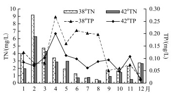
表层沉积物中TN和TP含量均是水道Ⅰ>水道Ⅱ(图 3).一方面是由于水道Ⅱ水较深且无植物,上游来水所受阻力小,流速相对较快,污染物沉积作用相对水道Ⅰ较弱;另一方面,通过对38#和42#(分别为水道Ⅰ和水道Ⅱ入水口处)样点12个月的水质分析发现,12个月中有9个月38#样点水体TN、TP浓度较42#样点的高(P<0.01)(图 4),表明外源氮、磷输入以水道Ⅰ为主.由此可以推断,沉积物氮、磷的空间分布受外源输入的影响.

|
图 4 38#和42#样点水体中总氮和总磷浓度 Fig.4 Total nitrogen and total phosphorus concentrations of 38# and 42# sampling sites |
目前对浅水湖泊沉积物的污染状况尚无统一的评价方法和标准,多用有机指数(OI)和有机氮(ON)评价法[28],只考虑了OM和ON,而忽略了磷;有的采用加拿大安大略省环境和能源部(1992年)制定的环境质量评价标准[29-33],该标准根据底泥中污染物对底栖生物的生态毒性效应进行分级,虽然后者考虑到磷,但此标准源于对海洋底泥的生态毒性分析.因此本文针对罗时江河口湿地表层沉积物的氮、磷和OM的分布特点,用综合污染指数评价法和有机指数评价法来评价罗时江河口湿地表层沉积物的污染现状.
4.1 综合污染指数评价本文以采用的TN和TP的评价标准(0.55和0.60 g/kg),与加拿大安略省环境和能源部(1992)发布的指南中沉积物中能引起最低级别生态风险效应的TN和TP含量相一致[32].单项污染指数计算公式为[34]:
| $ {S_i} = {C_i}/{C_{\rm{s}}} $ | (1) |
| $ FF = \sqrt {\frac{{{F^2} + F_{\max }^2}}{2}} $ | (2) |
式中,Si为单项评价指数或标准指数,Si>1表明含量超过评价标准值;Ci为评价因子i的实测值(g/kg);Cs为评价因子i的评价标准值(g/kg). TN的Cs为0.55 g/kg,TP的Cs为0.60 g/kg[35];FF为综合污染指数;F为n项污染物污染指数平均值(STN和STP的平均值);Fmax为最大单项污染指数(STN和STP的最大值).罗时江河口湿地表层沉积物氮、磷污染评价及污染程度分级结果见表 1和表 2.
| 表 1 罗时江河口湿地表层沉积物综合污染评价* Tab.1 Comprehensive pollution assessment for the surface sediments of the estuarine wetland of Luoshi River |
| 表 2 罗时江河口湿地表层沉积物综合污染程度分级 Tab.2 Standard and level of comprehensive pollution for the surface sediments of the estuarine wetland of Luoshi River |
根据表 1中综合污染指数,可得到罗时江河口湿地表层沉积物的污染分布(图 5).结合表 2和图 5可知综合污染指数大小为:Ⅰ区>Ⅱ区,水道Ⅰ>水道Ⅱ,且Ⅰ区和水道Ⅰ均属于中度污染,Ⅱ区和水道Ⅱ均属于轻度污染.

|
图 5 罗时江河口湿地表层沉积物的综合污染分布 Fig.5 Distribution of comprehensive pollution for the surface sediments of the estuarine wetland of Luoshi River |
综合污染指数法忽略了OM指标,考虑到近年来沉积物富营养化最主要的原因是有机物、氮、磷的迅速增加,所以本文用有机污染指数法[37]对罗时江河口湿地沉积物污染现状进一步评价,使评价结果更完善.有机污染指数评价法将选用的评价参数TN、TP综合成一个概括的指数值来表征底泥污染程度,其相对于综合污染指数法而言具优越性,是综合信息输出[38].根据公式(3)~(5)并结合表 3,罗时江河口湿地表层沉积物有机污染评价结果见表 4.
| $ OI = {\rm{OC}}\left( \% \right) \times {\rm{ON}}\left( \% \right) $ | (3) |
| $ {\rm{ON}} = {\rm{TN}}\left( \% \right) \times 0.95 $ | (4) |
| $ {\rm{OC}} = {\rm{OM}}\left( \% \right) \times 1.724 $ | (5) |
| 表 3 罗时江河口湿地表层沉积物的有机指数评价标准 Tab.3 Assess standards of organic index for the surface sediments of the estuarine wetland of Luoshi River |
| 表 4 罗时江河口湿地表层沉积物的有机污染评价 Tab.4 Organic pollution assessment for the surface sediments of the estuarine wetland of Luoshi River |
式中,OC为有机碳.
罗时江河口湿地有机污染分布情况为:Ⅰ区>Ⅱ区,水道Ⅰ>水道Ⅱ,总体为中度污染,局部(水道Ⅰ和水道Ⅱ)属于重度污染(表 4).
FF和OI的评价结果较为一致,罗时江河口湿地沉积物均表现为Ⅰ区>Ⅱ区,水道Ⅰ>水道Ⅱ. FF指数表明,水道Ⅰ和Ⅰ区属于中度污染水平,水道Ⅱ和Ⅱ区均属于轻度污染水平;OI指数表明,Ⅰ区和Ⅱ区均属于中度污染,水道Ⅰ和水道Ⅱ均属于重度污染水平.综上所述,该湿地表层沉积物综合污染和有机污染水平处于轻度与中度污染等级之间.与石勇[39]对巢湖塘西河河口湿地(总体上属于警戒等级,处于尚清洁水平)、陈如海等[28]对西溪湿地(富营养化程度比较严重)沉积物污染的评价结果相比,罗时江河口湿地表层沉积物污染水平与平原湿地存在差异.
5 结论罗时江河口湿地表层沉积物TN空间分布情况为Ⅰ区>Ⅱ区,水道Ⅰ>水道Ⅱ,TN含量在0.33~2.96 g/kg之间,平均值为0.94 g/kg;TP含量在0.04~1.28 g/kg之间,平均值为0.57 g/kg,空间分布情况为:Ⅰ区<Ⅱ区,水道Ⅰ>水道Ⅱ;OM含量在32.43~233.03 g/kg之间,平均值为78.54 g/kg,与TN和TP的空间分布不同,OM含量表现为:水道Ⅰ<水道Ⅱ,Ⅰ区<Ⅱ区.
沉积物氮、磷分布受外源输入影响,且罗时江河口湿地氮、磷污染主要来自水道Ⅰ和水道Ⅱ.养殖活动导致沉积物OM含量增加,对TP影响不显著.大量挺水植物分布会增加沉积物中总氮含量,降低总磷含量.运用FF分析表明:Ⅰ区和水道Ⅰ均属于中度污染,Ⅱ区和水道Ⅱ均属于轻度污染;运用OI分析表明:Ⅰ区和Ⅱ区均属于中度污染,水道Ⅰ和水道Ⅱ均属于重度污染. FF和OI的评价结果均表现为Ⅰ区>Ⅱ区,水道Ⅰ>水道Ⅱ.通过分析比较,罗时江河口湿地与平原地区湿地表层沉积物污染水平存在差异.
| [1] |
Cui Baoshan, Liu Xingtu. Discussion on some basic problems in design of wetland ecosystem. Chinese Journal of Applied Ecology, 2001, 12(1): 145-150. [崔保山, 刘兴土. 湿地生态系统设计的一些基本问题探讨. 应用生态学报, 2001, 12(1): 145-150.] |
| [2] |
Li Yinxi, Hu Yaohui, Wang Yunhua et al. Wetland restoration and its purification efficiency in estuary of Dajie River, Lake Xingyun, Yunnan Province. J Lake Sci, 2007, 19(3): 283-288. [李荫玺, 胡耀辉, 王云华等. 云南星云湖大街河口湖滨湿地修复及净化效果. 湖泊科学, 2007, 19(3): 283-288. DOI:10.18307/2007.0309] |
| [3] |
Yang Yang, Liu Qigen, Hu Zhongjun et al. Spatial distribution of sediment carbon, nitrogen and phosphorus and pollution evaluation of sediment in Taihu Lake Basin. Acta Scientiae Circumstantiae, 2014, 34(12): 3057-3064. [杨洋, 刘其根, 胡忠军等. 太湖流域沉积物碳氮磷分布与污染评价. 环境科学学报, 2014, 34(12): 3057-3064.] |
| [4] |
Bootsma MC, Barendregt A, Alphen JCA. Effectiveness of reducing external nutrient load entering a eutrophicated shallow lake ecosystem in the Naardermeer nature reserve, the Netherlands. Biological Conservation, 1999, 90(3): 193-201. DOI:10.1016/S0006-3207(99)00027-0 |
| [5] |
Xu Jin, Xu Ligang, Gong Ran et al. Adsorption and release characteristic of phosphorus and influential factors in Poyang Lake sediment. Ecology and Environment Sciences, 2014, 23(4): 630-635. [徐进, 徐力刚, 龚然等. 鄱阳湖沉积物中磷吸附释放特性及影响因素研究. 生态环境学报, 2014, 23(4): 630-635.] |
| [6] |
Wang Pei, Lu Shaoyong, Wang Dianwu et al. Nitrogen, phosphorous and organic matter spatial distribution characteristics and their pollution status evaluation of sediments nutrients in lakeside zones of Taihu Lake. China Environmental Science, 2012, 32(4): 703-709. [王佩, 卢少勇, 王殿武等. 太湖湖滨带底泥氮、磷、有机质分布与污染评价. 中国环境科学, 2012, 32(4): 703-709.] |
| [7] |
Zhao Xingqing, Yang Liuyan, Yu Zhenyang et al. Temporal and spatial distribution of physicochemical characteristics and nutrients in sediments of Lake Taihu. J Lake Sci, 2007, 19(6): 698-704. [赵兴青, 杨柳燕, 于振洋等. 太湖沉积物理化性质及营养盐的时空变化. 湖泊科学, 2007, 19(6): 698-704. DOI:10.18307/2007.0612] |
| [8] |
Lu Shaoyong, Xu Mengsuang, Jin Xiangcan et al. Pollution characteristics and evaluation of nitrogen, phosphorus and organic matter in surface sediments of Lake Changshouhu in Chongqing, China. Chinese Journal of Environmental Science, 2012, 33(2): 393-398. [卢少勇, 许梦爽, 金相灿等. 长寿湖表层沉积物氮磷和有机质污染特征及评价. 环境科学, 2012, 33(2): 393-398.] |
| [9] |
Zhang Qinghai, Lin Changhu, Tan Hong et al. Accumulation, distribution and pollution assessment of heavy metals in surface sediment of Caohai Plateau Wetland, Guizhou Province. Environmental Science, 2013, 34(3): 1055-1061. [张清海, 林昌虎, 谭红等. 草海典型高原湿地表层沉积物重金属的积累、分布与污染评价. 环境科学, 2013, 34(3): 1055-1061.] |
| [10] |
Zhao Haichao, Wang Shengrui, Jiao Lixin et al. Characteristics of temporal and spatial distribution of different forms of phosphorus in the sediments of Erhai Lake. Research of Environmental Sciences, 2013, 26(3): 227-234. [赵海超, 王圣瑞, 焦立新等. 洱海沉积物中不同形态磷的时空分布特征. 环境科学研究, 2013, 26(3): 227-234.] |
| [11] |
Chen Yongchuan, Tang Li, Zhang Degang et al. The spatially and temporally dynamic variation of total phosphorus in sediment of Dianchi Lake. Journal of Agro-Environment Science, 2007, 26(1): 51-57. [陈永川, 汤利, 张德刚等. 滇池沉积物总磷的时空分布特征研究. 农业环境科学学报, 2007, 26(1): 51-57.] |
| [12] |
Zhang Yuxi, Liu Jingtao, Wang Jincui et al. Distribution of phosphorus in the sediments of Yangzonghai Lake and its influencing factors. Safety and Environmental Engineering, 2013, 20(6): 43-48. [张玉玺, 刘景涛, 王金翠等. 阳宗海沉积物中磷的分布及其影响因素. 安全与环境工程, 2013, 20(6): 43-48.] |
| [13] |
Zhang Na, Li Hongjing, Yuan Lingwei et al. Characteristics of organic carbon, nitrogen and phosphorus in surface sediments of typical littorals of three lake regions on Qinghai-Tibet Plateau. Journal of Shaanxi Normal University (Natural Science Edition), 2010, 14(3): 70-75. [张娜, 李红敬, 远凌威等. 青藏高原典型湖泊湖岸带表层沉积物碳、氮、磷分析. 陕西师范大学学报:自然科学版, 2010, 14(3): 70-75.] |
| [14] |
Yu Hui, Zhang Wenbin, Lu Shaoyong et al. Spatial distribution characteristics of surface sediments nutrients in Lake Hongze and their pollution status evaluation. Environmental Science, 2010, 31(4): 961-968. [余辉, 张文斌, 卢少勇等. 洪泽湖表层底质营养盐的形态分布特征与评价. 环境科学, 2010, 31(4): 961-968.] |
| [15] |
Yi Wenli, Wang Shengrui, Jin Xiangcan et al. Distribution of total organic matter and the forms on the sediments from shallow lakes in the middle and lower reaches of the Yangtze River. Journal of Northwest University (Natural Science Edition), 2008, 36(5): 141-148. [易文利, 王圣瑞, 金相灿等. 长江中下游浅水湖沉积物中有机质及其组分的赋存特征. 西北农林科技大学学报:自然科学版, 2008, 36(5): 141-148.] |
| [16] |
Tan Zhen.Vertical changes of nutrients in the sediments of urban lakes in Guangdong[Dissertation].Guangzhou:Jinan University, 2006. [谭镇. 广东城市湖泊沉积物营养盐垂直变化特征研究[学位论文]. 广州: 暨南大学, 2006. http://cdmd.cnki.com.cn/Article/CDMD-10559-2007043918.htm ]
|
| [17] |
Li Wenchao. Nitrogen accumulation in the sediment of East Taihu Lake and biological sedimentation of aquatic plants. China Environmental Science, 1997, 17(5): 418-421. [李文朝. 东太湖沉积物中氮的积累与水生植物沉积. 中国环境科学, 1997, 17(5): 418-421.] |
| [18] |
Zhao Haichao, Wang Shengrui, Jiao Lixin et al. Characteristics of composition and spatial distribution of organic matter in the Sediment of Erhai Lake. Research of Environmental Sciences, 2013, 26(3): 243-249. [赵海超, 王圣瑞, 焦立新等. 洱海沉积物有机质及其组分空间分布特征. 环境科学研究, 2013, 26(3): 243-249.] |
| [19] |
Yang Qingxin, Li Wenchao. Environmental changes since foundation of pen-fish-farming in East Taihu Lake. China Environmental Science, 1996, 16(2): 101-106. [杨清心, 李文朝. 东太湖围网养鱼后生态环境的演变. 中国环境科学, 1996, 16(2): 101-106.] |
| [20] |
A guidance manual to support the assessment of contaminated sediments in freshwater ecosystems.US.EPA, 2002.
|
| [21] |
Sun Xiaojing, Qin Boqiang, Zhu Guangwei et al. Release of colloidal N and P from sediment of lake caused by continuing hydrodynamic disturbance. Environmental Science, 2007, 28(6): 1223-1229. [孙小静, 秦伯强, 朱广伟等. 持续水动力作用下湖泊底泥胶体态氮、磷的释放. 环境科学, 2007, 28(6): 1223-1229.] |
| [22] |
Zhang Yunlin, Qin Boqiang, Chen Weimin et al. A study on total suspended matter in Lake Taihu. Resources and Environment in the Yangtze Basin, 2004, 13(3): 266-271. [张运林, 秦伯强, 陈伟民等. 太湖水体中悬浮物研究. 长江流域资源与环境, 2004, 13(3): 266-271.] |
| [23] |
Beutel MW, Leonard TM, Dent SR et al. Effects of aerobic and anaerobic conditions on P, N, Fe, Mn, and Hg accumulation in waters overlaying profundal sediments of an oligo-mesotrophic lake. Water Research, 2008, 42(8/9): 1953-1962. |
| [24] |
Liu JJ, Wang JQ, Xu WX. Effects of environmental factors on NH4+ release in sediments from Chaohu Lake. Agricultural Science & Technology, 2008, 9(3): 153-156. |
| [25] |
Pan Qikun, Luo Zhuanxi, Qiu Zhaozheng et al. Distribution characteristics of nitrogen forms in surface sediments of Jiulongjiang Estuary Wetland. Research of Environmental Sciences, 2011, 24(6): 673-678. [潘齐坤, 罗专溪, 邱昭政等. 九龙江口湿地表层沉积物氮的形态分布特征. 环境科学研究, 2011, 24(6): 673-678.] |
| [26] |
Squires MM, Lesack LF. The relation between sediment nutrient content and macrophyte biomass and community structure along a water transparency gradient among lakes of the Mackenzie Delta. Canadian Journal of Fisheries and Aquatic Sciences, 2003, 60(3): 333-343. DOI:10.1139/f03-027 |
| [27] |
Horppila J, Nurminen L. Effects of different macrophyte growth forms on sediment and P resuspension in a shallow lake. Hydrobiologia, 2005, 545(1): 167-175. DOI:10.1007/s10750-005-2677-9 |
| [28] |
Chen Ruhai, Zhan Liangtong, Chen Yunmin et al. Contents of nitrogen, phosphorus and organic materials in sediments and their distribution along depth at Xixi Wetland. China Environmental Science, 2010, 30(4): 493-498. [陈如海, 詹良通, 陈云敏等. 西溪湿地底泥氮、磷和有机质含量竖向分布规律. 中国环境科学, 2010, 30(4): 493-498.] |
| [29] |
Calmano W, Ahlf W, Forstner U.Sediments quality assessment:Chemical and biological approaches.Berlin:Springer, 1996:1-35.
|
| [30] |
Wu Ming, Shao Xuexin, Jiang Keyi. Characteristics and assessment on nutrient distribution in water and sediments of Xixi National Wetland Park in Hangzhou. Forest Research, 2008, 21(4): 587-591. [吴明, 邵学新, 蒋科毅. 西溪国家湿地公园水体和底泥N-P营养盐分布特征及评价. 林业科学研究, 2008, 21(4): 587-591.] |
| [31] |
Leivuori M, Niemisto L. Sedimentation of trace metals in the Gulf of Bothnia. Chemosphere, 1995, 31(8): 3839-3856. DOI:10.1016/0045-6535(95)00257-9 |
| [32] |
Wei Linying, Bu Xianwei. Present assessment of environmental quality in sea area near Daao, Liuheng Island. Donghai Marine Science, 1991, 17(1): 66-71. [魏琳瑛, 卜献卫. 六横大岙附近海域环境质量现状评价. 东海海洋, 1991, 17(1): 66-71.] |
| [33] |
Fang Yuqiao, Qiu Zu'nan, Ma Meifang et al. Enactment of the standard concerning polluted sediment types in the rivers. Environmental Science, 1989, 10(1): 27-30. [方宇翘, 裘祖楠, 马梅芳等. 河流底泥污染类型标准的制定. 环境科学, 1989, 10(1): 27-30.] |
| [34] |
Yue Weizhong, Huang Xiaoping, Sun Cuici. Distribution and pollution of nitrogen and phosphorus in surface sediments from the pearl river estuary. Oceanologia et Limnologia Sinica, 2007, 38(2): 111-117. [岳维忠, 黄小平, 孙翠慈. 珠江口表层沉积物中氮、磷的形态分布特征及污染评价. 海洋与湖沼, 2007, 38(2): 111-117.] |
| [35] |
Wang Sumin, Dou Hongshen. Chinese lakes record. Beijing: Science Press, 1998. [王苏民, 窦鸿身. 中国湖泊志. 北京: 科学出版社, 1998.]
|
| [36] |
Fan Zhijie. Study on definition of marine sediment criteria by equilibrium partitioning method. Environmental Protection in Transportation, 1999, 20(1): 21-25. [范志杰. 浅谈海洋沉积物标准的几个问题. 交通环保, 1999, 20(1): 21-25.] |
| [37] |
Li Renwei, Li He, Li Yuan et al. Study of heavy metals, nitrogen and phosphorus contaminants in the sediments of the Yellow River Delta in the sediments of the Yellow River Delta. Acta Sedimentologica Sinica, 2001, 19(4): 622-629. [李任伟, 李禾, 李原等. 黄河三角洲沉积物重金属、氮和磷污染研究. 沉积学报, 2001, 19(4): 622-629.] |
| [38] |
Ding Jing.Characteristics of nitrogen and phosphorus distribution in Taihu Lake and its adsorption/desorption characteristics of the study[Dissertation].Nanjing:Nanjing University of Science and Technology, 2010. [丁静. 太湖氮磷分布特征及其吸附/解吸特征研究[学位论文]. 南京: 南京理工大学, 2010. http://cdmd.cnki.com.cn/article/cdmd-10288-2010096864.htm ]
|
| [39] |
Shi Yong.Pollution characteristics analysis and environmental quality assessment of sediments for estuary wetland of Tangxihe River[Dissertation].Hefei:Hefei University of Technology, 2010. [石勇. 巢湖塘西河河口湿地沉积物污染特征及环境质量评价[学位论文]. 合肥: 合肥工业大学, 2009. http://cdmd.cnki.com.cn/Article/CDMD-10359-2009156073.htm ]
|
 2017, Vol. 29


